
Maryland, Pennsylvania, New Jersey, and Delaware Expected to See 6–10 Inches of Heavy Snow as Final Forecast Highlights Intense Overnight Snow Band
EASTERN UNITED STATES — A strengthening winter storm is poised to deliver widespread accumulating snow across Maryland, Pennsylvania, New Jersey, and Delaware tonight into Sunday morning, with updated short-term observations showing the potential for a high-impact 6–10 inch snow band across the region. Forecasters say the greatest accumulation is likely in northern Maryland and southeastern Pennsylvania, where atmospheric conditions are aligning for several hours of heavy snowfall.
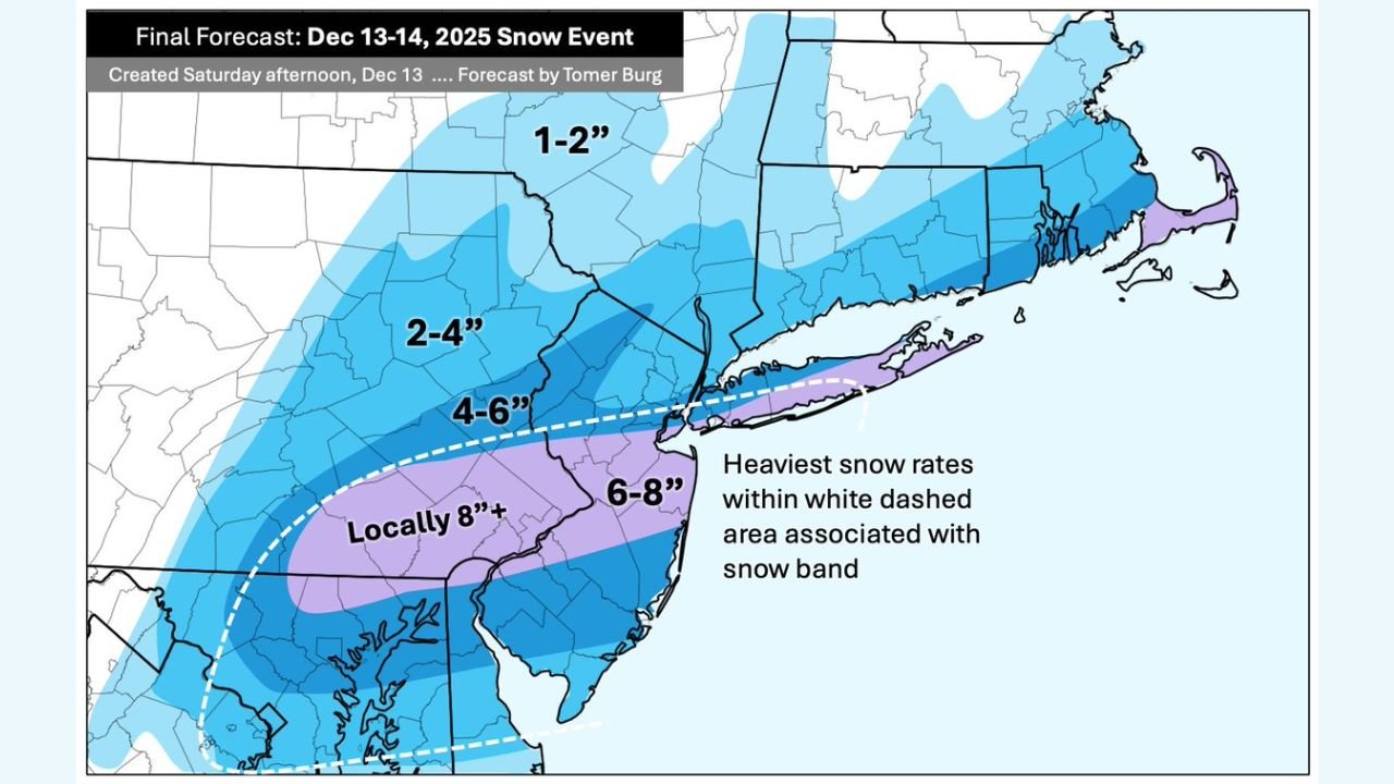
This final forecast reflects improving model agreement and more precise placement of the storm’s mesoscale snow band, which is expected to intensify rapidly overnight.
Snowfall Forecast Overview
6–10 Inches: Primary Heavy Snow Axis
The corridor of highest impact is expected across:
- Northern Maryland
- Southeastern Pennsylvania
- South-central New Jersey
- Northern Delaware
This zone falls beneath the strongest lift within the storm system, where snowfall rates may exceed one inch per hour at times and visibility could drop sharply.
Locally 8 Inches or More
Localized enhancement is possible across:
- Central Maryland
- Far southeastern Pennsylvania
- Northern Delaware
These areas lie within the white-dashed region on the final snow map, where banding could remain stationary for a period, allowing totals to exceed initial projections.
4–6 Inches
Widespread across:
- South-central Pennsylvania
- Much of New Jersey
- Northern Maryland
- Western Delaware
This area will experience steady moderate snow but sits just outside the core of the heaviest band.
2–4 Inches
Expected across:
- Northern Pennsylvania
- Northern New Jersey
- Parts of southern New York
1–2 Inches
The northern fringe of the storm, including:
- Upstate New York
- Far northern Pennsylvania
- Northern New England
These regions remain on the cooler, drier edge of the system.
Why the Forecast Shifted Today
Analysts adjusted projections based on:
- More robust lift on the synoptic scale
- Strengthening temperature gradients aiding band formation
- Increasing agreement among high-resolution models
- Clearer identification of the corridor most favorable for heavy snow
Short-term mesoscale observations also indicated a sharper and more energetic snow band than earlier model runs suggested.
Timing of the Storm
- Start: Evening hours tonight
- Peak snowfall: Overnight into early Sunday, when the heaviest bands move through
- End: Snow gradually tapers late Sunday morning
Road conditions will deteriorate quickly once heavy snow begins, especially within the 6–10 inch corridor.
Travel and Safety Considerations
Forecasters warn that sharply reduced visibility, snow-covered roads, and rapid accumulation may lead to:
- Difficult overnight travel
- Slow highway conditions across the Mid-Atlantic
- Hazardous morning commutes on Sunday
- Potential disruptions to regional transportation
Residents in the core snow band should avoid overnight travel if possible and plan for extended clearing and cleanup on Sunday morning.
Looking Ahead
As the storm exits, colder air will settle into the region, preserving snowpack and delaying melting. Forecast models will continue to refine residual snowfall and any potential secondary impacts such as refreezing.
ChicagoMusicGuide.com will monitor updates from regional forecasting centers and provide additional coverage if totals or timing shift.