
Georgia Winter Storm Recap: Heavy Snow Bands Slam Northeast and East Georgia as Atlanta Sees Limited Impact
GEORGIA — A late-January winter storm delivered a sharp contrast across the state, with Northeast Georgia and East Georgia seeing the heaviest snowfall from intense banding, while metro Atlanta and much of central and southern Georgia experienced little to no accumulation, according to preliminary data released by the National Weather Service Peachtree City/Atlanta.
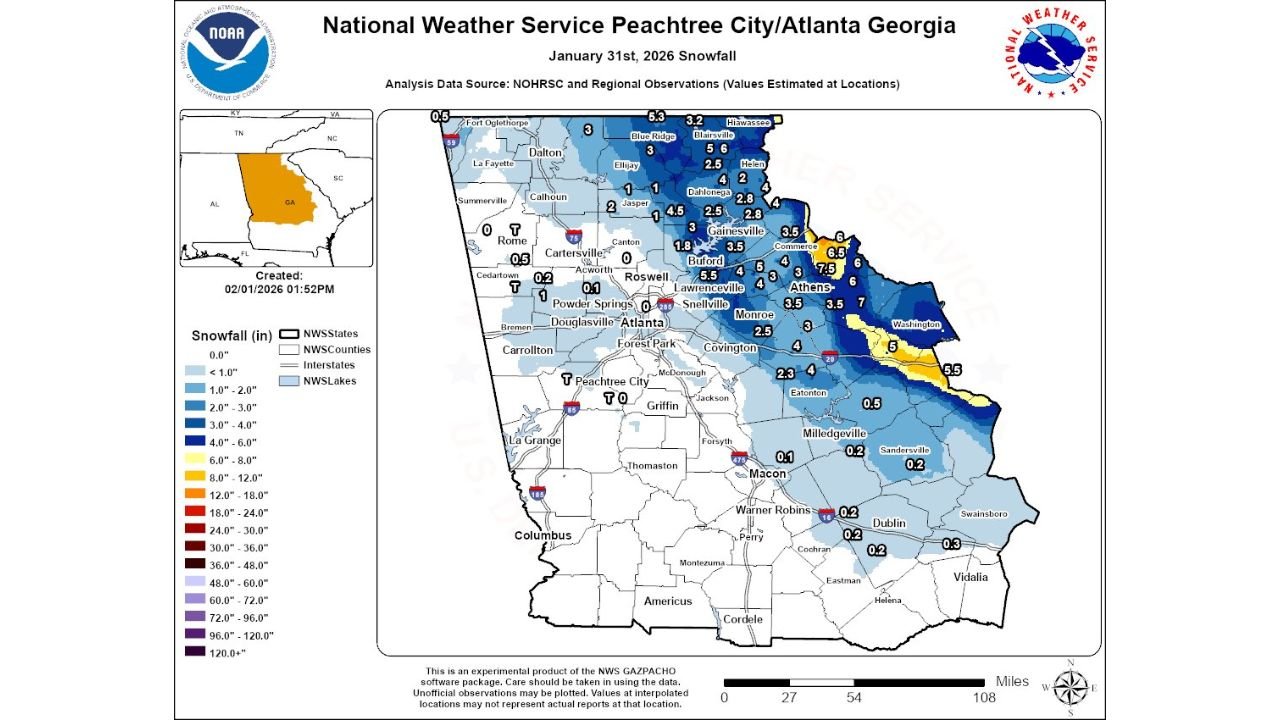
Heavy Snow Bands Focused on Northeast and East Georgia
The most significant impacts from the January 31, 2026 winter storm were concentrated across Northeast Georgia, where persistent snow bands set up for several hours. Communities in and around Athens, Washington, Gainesville, and the Blue Ridge foothills recorded 4 to 6 inches of snow, with localized pockets exceeding those totals where banding remained stationary the longest.
Forecasters noted two distinct corridors of heavier snowfall in eastern and northeastern portions of the state, a classic setup during cold-air-dominated systems when moisture aligns just enough to produce sustained snowfall rates. Elevation also played a role, especially across the north Georgia mountains, where colder surface temperatures supported efficient accumulation.
Metro Atlanta Largely Missed the Core of the Storm
In sharp contrast, Atlanta, Peachtree City, and much of the I-285 corridor saw little measurable snow. Many locations reported only a trace to under one inch, with some southern and western suburbs recording no accumulation at all.
The snowfall gradient was striking: areas just northeast of metro Atlanta transitioned quickly from light coatings to several inches of snow. This sharp cutoff highlights how sensitive winter storms in Georgia can be to subtle shifts in storm track and band placement.
Central and Southern Georgia Saw Minimal Accumulation
Across central Georgia, including Macon, Warner Robins, and Milledgeville, snowfall totals were generally under one inch, with many locations reporting only a dusting. Farther south toward Columbus, Americus, and Valdosta, no snow accumulation was observed, as the system weakened and moisture remained limited.
Road impacts in these regions were minimal, though colder temperatures following the storm did allow for brief slick spots early Saturday morning in isolated areas.
Why Snowfall Varied So Dramatically
Meteorologists emphasized that mesoscale snow banding was the key driver behind the uneven totals. While the storm system itself was not exceptionally strong, localized enhancement within the snow shield led to significant differences over relatively short distances.
In East and Northeast Georgia, banding persisted long enough to overcome marginal moisture levels, while areas farther west remained largely dry. This pattern underscores how winter weather in the Southeast often depends more on placement than overall storm strength.
What This Storm Says About Georgia’s Winter Pattern
This event continues a broader trend of impactful winter weather affecting populated areas across parts of the eastern United States this season. While Georgia avoided a widespread major snowstorm, the sharp impacts in Athens and surrounding counties reinforce how even modest systems can create localized disruptions when conditions align.
With cold air remaining entrenched across the region following the storm, forecasters advised residents in snow-affected areas to remain cautious of lingering icy patches, especially during overnight and early morning hours.
For continued coverage of Georgia weather, regional winter storm recaps, and updates that matter to travelers and eventgoers, stay connected with ChicagoMusicGuide.com for the latest forecasts and weather-driven news across the country.