
Maryland Winter Storm Threat Surges to 50–80% While Washington, D.C. Faces Lower Snow Odds in Developing Mid-Atlantic System
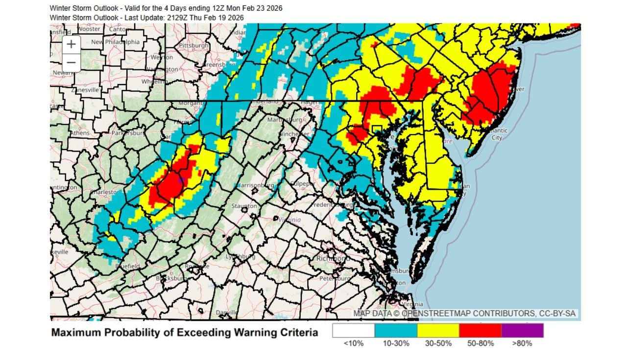
WASHINGTON, DISTRICT OF COLUMBIA — The latest National Weather Service Winter Storm Outlook highlights a sharp contrast in snowfall potential across the region, with Washington, D.C. currently carrying only a 10–30% chance of exceeding winter storm warning criteria, while parts of central and northeastern Maryland are seeing probabilities as high as 50–80%.
The updated outlook, valid through 12Z Monday, February 23, 2026, underscores how narrowly defined this developing winter storm could be — with higher snowfall probabilities shifting just north of the nation’s capital and into Maryland.
What “Exceeding Warning Criteria” Means in Washington, D.C.
Winter storm warning thresholds vary by local NWS office, but in the Washington, D.C. region, warning-level snowfall typically means the potential for 5 inches or more of snow within a defined time frame.
Under the current outlook:
- Washington, D.C.: 10–30% probability
- Central Maryland: 50–80% probability
- Northeastern Maryland: 50–80% probability
- Portions of western Maryland and eastern West Virginia also show elevated probabilities
This map represents the maximum probability of exceeding warning criteria, not guaranteed totals. It shows where forecasters believe the risk of reaching 5 inches or more is most concentrated.
Central and Northeastern Maryland Stand Out
The most striking feature on the outlook is a band of yellow and red shading stretching across central Maryland, extending toward the Baltimore metropolitan area and into northeastern Maryland counties.
Red-shaded zones signal a 50–80% chance of reaching warning-level snowfall — a strong indication that impactful accumulations are possible if the storm evolves as projected.
Meanwhile, Washington, D.C. remains in the lower 10–30% range, meaning the capital could either fall short of 5 inches or see totals highly dependent on subtle shifts in storm track.
Why the Snow Gradient Is So Tight
Mid-Atlantic winter storms often produce sharp snowfall cutoffs, and this system appears no different. Forecast guidance suggests the heaviest snow band may align just north of Washington, D.C., placing central Maryland in a favored position.
Factors contributing to the gradient include:
- Storm track position relative to the Chesapeake Bay
- Temperature profiles near the I-95 corridor
- Potential mesoscale banding across Maryland
A shift of even 25 to 50 miles could significantly alter totals, especially in densely populated corridors between Washington, D.C. and Baltimore, Maryland.
Timing Through Early Monday
The Winter Storm Outlook is valid for the four days ending 12Z Monday, February 23, 2026, suggesting primary impacts would occur late Sunday into early Monday morning.
If warning-level snowfall materializes in Maryland, potential impacts could include:
- Hazardous early Monday travel
- Snow-covered secondary roads
- Delays across the Baltimore–Washington corridor
While Washington, D.C. currently carries lower odds of exceeding 5 inches, accumulating snow remains possible depending on final band placement.
What Forecasters Are Watching Now
Meteorologists continue to monitor:
- Placement of the heaviest snow axis
- Temperature boundaries near the District
- Storm track adjustments over the next 24–48 hours
The developing system remains dynamic, and probability zones could shift as new data arrives.
As Maryland and Washington, D.C. prepare for a potentially impactful winter setup, small forecast changes could determine who sees routine snowfall and who crosses into warning-level territory. For continued Mid-Atlantic weather updates and storm analysis, visit ChicagoMusicGuide.com.