
Illinois Wisconsin and Iowa Residents Urged To Prepare As Tornado Threat Targets Areas Along And West Of I 39 Thursday Afternoon
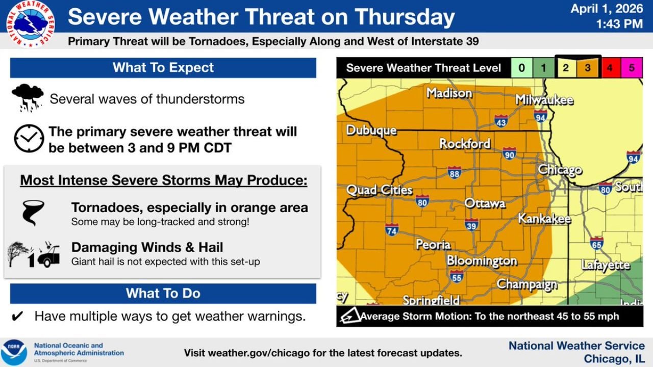
ILLINOIS — Residents across northern and central Illinois, southern Wisconsin, and eastern Iowa are being placed on alert as a regional severe weather threat is expected to intensify Thursday afternoon and evening, with conditions favoring tornado development across a large portion of the Midwest.
The most concerning area includes locations along and west of Interstate 39, covering cities such as Rockford, Ottawa, Bloomington, Peoria, the Quad Cities, and extending toward Dubuque and Madison.
Tornado Threat Expected To Peak Between 3 PM And 9 PM
Forecast timing shows the primary severe weather window will occur:
- Between 3 PM and 9 PM CDT
During this period:
- Multiple rounds of thunderstorms are expected to develop
- Storms will move northeast at speeds of 45 to 55 mph
- Conditions will become increasingly favorable for tornado-producing storms
Highest Risk Focused In Orange Shaded Corridor
The most dangerous zone is highlighted across:
- Eastern Iowa including the Quad Cities and Dubuque
- Northern and central Illinois including Rockford, Ottawa, Peoria, Bloomington, and areas west of Chicago
- Extending into southern Wisconsin near Madison
Within this corridor:
- Tornadoes are the primary concern
- Some tornadoes could become strong or long-tracked
- Storms may remain organized enough to sustain rotation over longer distances
Additional Hazards Include Damaging Winds And Hail
Along with tornado risk, storms may also produce:
- Damaging wind gusts capable of causing widespread impacts
- Hail, though extremely large hail is not expected to be the dominant hazard in this setup
These hazards could occur simultaneously, especially within stronger storm cells.
Multiple Waves Of Storms Expected
Forecast guidance indicates:
- More than one round of storms may impact the region
- Conditions may reload after initial storms, leading to additional severe development later in the evening
- This increases the chance for repeated impacts in some areas
Areas East Of Chicago Face Lower But Not Zero Risk
Regions east of the highest risk zone, including parts of:
- Chicago metro area
- Northwest Indiana
are in a lower risk category, but:
- Severe storms are still possible
- Conditions may still support isolated severe weather
Residents Urged To Take Precautions Ahead Of Storms
People across Illinois, Wisconsin, and Iowa should prepare before storms arrive:
- Ensure you have multiple ways to receive warnings
- Identify a safe shelter location immediately
- Monitor weather updates closely throughout the day
- Be ready to act quickly if warnings are issued
Fast Moving Storms Could Reduce Reaction Time
With storms expected to move quickly to the northeast, warning times may be limited in some areas.
This setup has the potential to bring rapidly developing severe weather across a broad region, especially along and west of I-39, making preparedness and awareness critical for residents across the Midwest.
Stay with ChicagoMusicGuide.com for real-time severe weather updates, tornado alerts, and critical safety information as this dangerous storm system develops across Illinois, Wisconsin, and Iowa. Share this update with friends and family in the impacted areas so they can stay prepared.